SEPTEMBER 2011
You Can't Get There From Here
Mark had told me about his trip to the central Eastern coast of Nova Scotia a few years before, and gave me to believe that it was not much different from the Maine coast. I'd taken no further notice until, while paging through Scott Cunningham's "Sea Kayaking in Nova Scotia" he made mention that the extreme northeastern coast (below Cape Breton) was more like Newfoundland geologically. It was an isolated area with many islands. My requirements are few for interest in a trip: whales, icebergs, or islands. So it met the criteria. I made plans, gathered charts and food and gear, and set out for Little Dover, NS.
Let me say that the reason I take these trips, often solo (as this one was), is not to be bold and adventurous, nor to cover many miles, but to have a nice vacation. I have a boat, there are beautiful places I can reach by using it, and it costs very little to do so. With good judgment, there should be no wild adventures, only enjoyment of a wonderful new place. I strive to be adventure-free. I'd enjoy company on these trips, but often there is no one who is able or interested in going at the time or to the place that I choose. Rather than forgo the experience, I go alone. It makes the trip different, but not diminished.

Here is the map of the route from where I live in Massachusetts to Little Dover, NS. Google maps said 14 hours, but it took me 12. I stopped the first night in Antigonish, at the Claymore Inn which I highly recommend. From there it was under 2 hours to Little Dover the next morning. Once again, books-on-tape made the drive not only tolerable but pleasant.

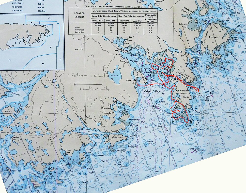
My plan was to start northward toward Canso, then come back past Little Dover southward to Whitehead Bay and Tor Bay (off left side of chart), then back to Little Dover. This way I would never be very far from my starting point, in case of bad weather, and I could restock water on the way south. It was a pretty good plan, and like many good plans, it didn't turn out that way.
I parked in Black Duck Cove Provincial Park at the end of Little Dover Road. A man who was walking there advised me as to where I might park in order to be closest to the water. I parked and began to unload the boat and stage supplies and gear. Another man drove up in a truck. I asked him if it would be okay for me to leave the car there for a week while I kayaked. He said yes, no one would bother it and it wasn't in the way. He advised me to be very careful going northward, that in bad weather that coast was very rough. He suggested that I check out the upper reaches of Dover Harbor, where he once had a cabin. Very pretty, he said. I thought it a good suggestion if the weather got bad, and kept it in mind.
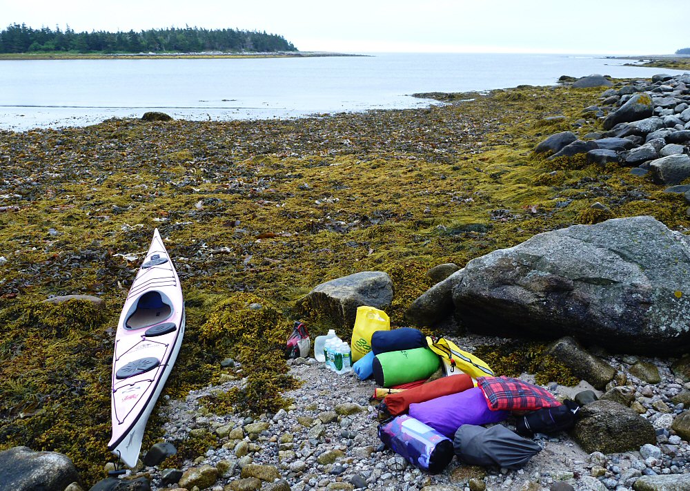
Here is the launch site in Black Duck Cove. It was full low tide but the heavy growth of seaweed actually made it very easy to slide the loaded kayak out to the water. I was off by 8:30 a.m., weather overcast but warm and mild, with a light breeze. Out the cove and northward across the mouth of Dover Harbor, I paddled toward the massive tongue of land that is Little Dover Island. Out at the tip I could see breakers washing against the rocks, but inside it was calm. I was surprised that the water temp was not frigid like that of the Bay of Fundy or Newfoundland - I'm guessing maybe 50 degrees. I found the entrance to Little Dover Run, the passage between Little Dover Island and the mainland. There were a few houses there - it reminded me of the inside passage between the two Exploits Islands in NFL.
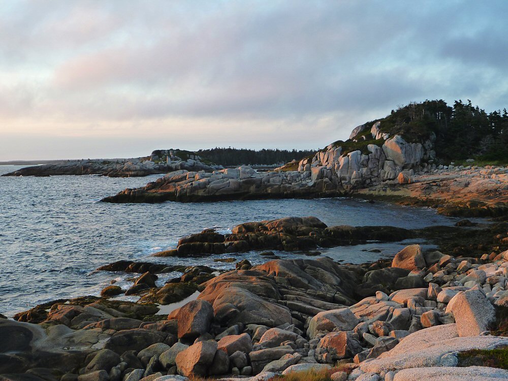
Coming out of Little Dover Run, the North Atlantic opened up before me. Bare granite rimmed the exit.

As I paddled past the rock, the ocean swell came forward to meet me. I had been in the fully loaded boat for less than an hour in this place where I had never been before, and suddenly I felt very small and uncertain. I paddled out farther, to a panorama of surf on rock, explosive offshore shoals, the boom of waves smashing into granite. Looking down the coast I saw more of the same, off into the mist. A flashback came to me of paddling around Point Enrage at the Mingan Archipelago - a situation I'd promised myself I'd never put myself through on a solo trip again. From a distance it looked calm but the ocean was bobbing me around and pushing me where I wasn't at all sure I wanted to go. I paddled hurriedly back inside.

I found a place on the rocky shore to pull over and consider. Was I foolish to turn back from this first challenge? or wise? I remembered the guidebook warning, that this was a headland to take seriously and that one should give consideration to using the portage at Portage Cove. I went to look for it.
I also remembered an account I'd read by another paddler who had similarly looked for this cove and could not find it. This part of the harbor is a maze of islands, dot after dot of spruce on granite. I searched but did not find the magical cove, and wasn't sure I could do the portage anyway. I decided to explore locally, go south for the first part of the trip, and head north again at the end if the weather would permit. It was a great disappointment to me but Little Dover Island soon helped me to forget this.

next page